|
ANTELOPE VALLEY GROUND WATER
|
(the following text and images were obtained from the
internet address below)
http://wwwcapp.er.usgs.gov/publicdocs/gwa/ch_b/ha730btext
Single, Undrained, Closed Basin
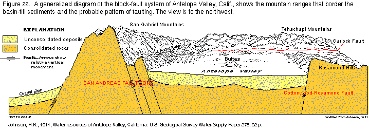
Antelope Valley, Calif., which is an example of a single, undrained,
closed basin, is a large topographic and ground-water basin in
the western part of the Mojave Desert in southern California.
Antelope Valley occupies part of a structural depression that
has been downfaulted between the Garlock and the CottonwoodRosamond
Faults and the San Andreas Fault Zone (fig. 26).
Consolidated rocks that yield virtually no water underlie the
basin and crop out in the highlands that surround the basin. They
consist of igneous and metamorphic rocks of pre-Tertiary age that
are overlain by indurated continental rocks of Tertiary age interbedded
with lava flows. Alluvium and interbedded lacustrine deposits
of Quaternary age are the important aquifers within the closed
basin and have accumulated to a thickness of as much as 1,600
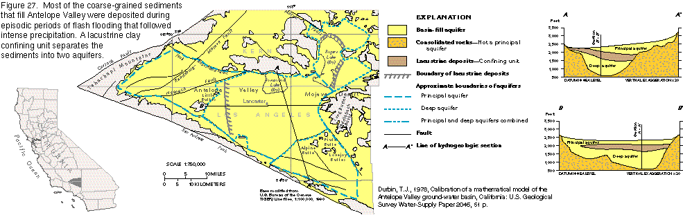
feet (fig. 27).
The alluvium is unconsolidated to moderately consolidated,
poorly sorted gravel, sand, silt, and clay. Older units of the
alluvium are more compact and consolidated, somewhat coarser grained,
more weathered, and more poorly sorted than the younger units.
The rate at which water moves through the alluvium (the hydraulic
conductivity of the alluvium) decreases with increasing depth.
During the depositional history of Antelope Valley, a large
intermittent lake occupied the central part of the basin and was
the site of accumulation of fine-grained material. The rates of
deposition varied with the rates of precipitation. During periods
of relatively heavy precipitation, massive beds of blue clay formed
in a deep perennial lake. During periods of light precipitation,
thin beds of clay and evaporative salt deposits formed in playas
or in shallow intermittent lakes. Individual beds of the massive
blue clay can be as much as 100 feet thick and are interbedded
with lenses of coarser material as much as 20 feet thick. The
clay yields virtually no water to wells, but the interbedded coarser
material can yield considerable volumes of water. During deposition
of the lacustrine deposits, alluvial material that was supplied
from the San Gabriel Mountains encroached upon the lake and forced
it northward, which resulted in a northward transgression of alluvium
over lacustrine deposits. The subsurface extent of the buried
lacustrine deposits is shown in figure 27. The lacustrine deposits
underlie the central part of the basin and have a somewhat lenticular
shape. The thickest section is near the center of the basin, and
the deposits thin towards the edges of the basin. Near Little
Buttes and near the east and north edges of Rogers Lake, the deposits
pinch out (fig. 27, section BB¹).
Along the northern and southern boundaries of the basin, the
lacustrine deposits are about 100 and 400 feet thick, respectively,
where they abut buried escarpments of consolidated rocks (fig.
27, section AA¹).
Near the southern limit of the basin, southeast of Lancaster,
the lacustrine deposits are buried beneath about 800 feet of alluvium,
but near Rosamond Lake, they are exposed at the surface (fig.
27, section AA¹).
Two aquifers, which are separated by the lacustrine deposits,
are in the alluvial material (fig. 27).
The upper aquifer is the principal and most used aquifer and
contains water under unconfined, or water table, conditions. Where
the lower, or deep, aquifer underlies lacustrine deposits, it
contains water under confined, or artesian, conditions; elsewhere,
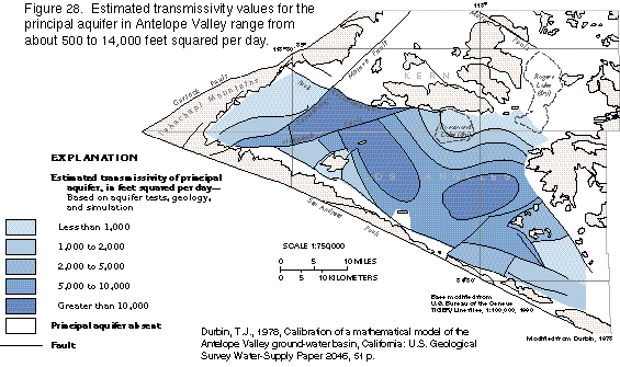
unconfined conditions prevail. Transmissivity values for the principal
aquifer (fig. 28) are estimated to range from less
than 1,000 to more than 10,000 feet squared per day.
The transmissivity of an aquifer is a measure of how rapidly
water will pass through the aquifer; the greater the transmissivity,
the faster the movement of the water and the more water the aquifer
will yield to wells. Where the principal aquifer is thin, either
near its boundaries or on the uplifted parts of fault blocks,
its transmissivity is low; where the aquifer is thick or consists
of coarse-grained deposits, or both, the transmissivity is high.
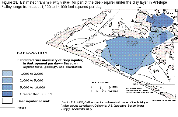
The estimated transmissivity of the deep aquifer (fig. 29) ranges
from about 2,000 to 10,000 feet squared per day and is greatest
where the aquifer is thick.
The transmissivity of the deep aquifer
varies less than that of the principal aquifer (compare figs.
28 and 29) probably because the thickness of the deep aquifer
is more uniform than that of the principal aquifer. Ground water
in the Antelope Valley Basin moves from the base of the San Gabriel
and the Tehachapi Mountains toward Rosamond Lake in the north-central
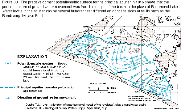
part of the basin (fig. 30).
As ground water moves eastward across the western limit of
the lacustrine deposits, part of the water moves above the lacustrine
deposits to recharge the principal aquifer and part moves below
the lacustrine deposits to recharge the deep aquifer. Major faults
that cut the alluvial deposits in Antelope Valley, especially
the RandsburgMojave Fault (fig. 30), act as partial barriers
to the movement of ground water. Water-level differences of more
than 300 feet in the same aquifer are present across the RandsburgMojave
Fault. Along several other faults, the water table is several
tens of feet higher on the upgradient side of the fault than on
the downgradient side. An estimate of the shape of the predevelopment
potentiometric surface of the principal aquifer in 1915 (fig.
30) shows that before extensive pumping began, the water table
was near the land surface in the central part of the basin; ground
water moved northward and northeastward, and discharged by evapotranspiration
at Rosamond Lake, which was dry. Withdrawal of ground water from
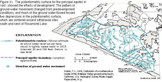
the principal aquifer and the subsequent lowering of the water
table reduced this natural discharge. By 1961, the direction of
ground-water movement in the principal aquifer had been reversed
from northeastward to southward and southeastward, toward the
center of the basin in the area immediately southeast of Rosamond
Lake (fig. 31).
The main change in the potentiometric surface was the development
of areas of low water levels near the withdrawal centers and the
resultant reversal in the direction of ground-water flow near
these areas. Ground water leaks through the lacustrine deposits
between the principal and deep aquifers even though the lacustrine
deposits do not readily yield water to wells. Based on the hydraulic
heads for the two aquifers, water leaks downward along the western
and southern periphery of the lacustrine deposits. In the north-central
part of the area underlain by the lacustrine deposits, water leaks
upward. Because of the large withdrawals from the principal aquifer,
the area of upward leakage has expanded toward the areas of concentrated
withdrawal (fig. 31). The aquifers in Antelope Valley are recharged
primarily by infiltration of streamflow that originates in the
mountainous areas that surround the valley. The average annual
precipitation on the valley floor is less than 10 inches, and
runoff is minor. For the most part, streamflow that enters the
valley is intermittent. During storm periods, streamflow enters
the valley along its perimeter and moves across the surface of
the alluvial fans toward the playas at Rosamond and Rogers Lakes.
As the streams flow across the alluvial fans, all the streamflow
generally infiltrates the permeable surficial deposits on the
fans. Because of the desert conditions, much of the infiltrating
water is quickly lost by evaporation or as transpiration by riparian
vegetation. The remainder of the water infiltrates downward through
the alluvial deposits until it reaches the water table. The drainage
area tributary to Antelope Valley is about 385 square miles. Runoff
from about 20 percent of this area is measured and the collective
average annual discharge at the measured points is about 24,300
acre-feet. By calculating the measured runoff per unit area and
extrapolating this value to unmeasured areas, the total runoff
that enters the valley was estimated to be 40,700 acre-feet. Evapotranspiration
is the major natural discharge of ground water in Antelope Valley.
Ground water generally discharges by evaporation from the water
table where the water table is within 10 feet of the land surface,
and, where vegetation is present, transpiration may also occur.
Evaporation from an open body of water in Antelope Valley was
measured at about 114 inches per year, which is an upper limit
for evaporation of ground water. Because evapotranspiration from
the ground-water system is complex, exact values cannot be determined.
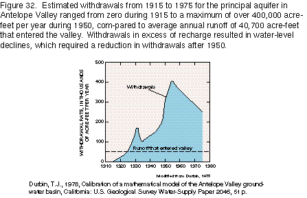
The use of ground water for agriculture in Antelope Valley began
about 1880, when wells were drilled near the center of the valley
and yielded flowing water in quantities sufficient for irrigation.
In 1891, more than 100 wells were in use, but most had stopped
flowing. About 1915, intense use of ground water began when a
large number of wells were drilled and equipped with pumps. An
estimate of annual withdrawal rates from 1915 to 1975 is shown
in figure 32.
The maximum rate of withdrawal of about 400,000
acre-feet per year is about 10 times the estimated annual recharge
to the basin. Water removed from storage in the aquifers was a
major part of the ground-water withdrawals, and severe water-level
declines resulted. By about 1950, studies showed that ground-water
withdrawals in the valley were greatly in excess of natural recharge
and withdrawals were curtailed. The geographic distribution of
withdrawals was generally unchanged between 1915 and 1960. After
1960, withdrawals were redistributed by abandoning some wells
and adding some new wells. With the new distribution, the center
of withdrawal was split into two areas; one was approximately
5 miles southeast, and the other approximately 10 miles southwest
of Rosamond Lake (fig. 31).
Withdrawals from the deep, or confined,
aquifer in Antelope Valley have caused an increase in leakage
to the deep aquifer from the principal aquifer along the western
and southern peripheries of the lacustrine deposits. This leakage
has locally lowered the water table in the principal aquifer and
has resulted in the reduction of natural discharge from the aquifer.
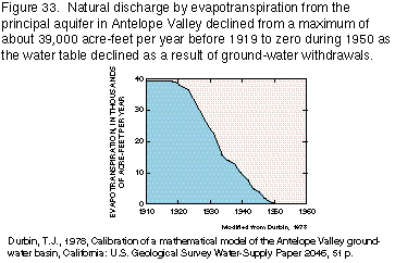
Most of the declines in the principal aquifer, however, are the
consequence of withdrawals from that aquifer. Field data are not
available to show the effects of water-level declines on the amount
of natural discharge, but the results of a digital flow model
indicate that most of the natural evapotranspiration from the
center of the valley might have ceased by 1950 (fig. 33) because
water levels in the principal aquifer were too deep to allow evaporation
or transpiration.
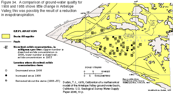
Ground water in closed basins is commonly highly mineralized
because discharge by evapotranspiration increases the concentrations
of minerals in the water. Some of the minerals might precipitate
at or near the center of the basin. However, dissolved-solids
concentrations in ground water remained practically the same or
decreased slightly in Antelope Valley between 1908 and 1955 (fig.
34); this was probably caused by the reduced evapotranspiration
that resulted from declining water levels in the principal aquifer.